Monday, March 14, 2011

Canyon of the Ancients

Back today from a weekend at Canyon of the Ancients in SW Colorado. Bill Priedhorsky, fearless leader of the previous canyoneering experience, organized this one as well. I will add, he did a great job. There were probably 40 of us, and we all managed to arrive on Thursday night, get up in the morning and be organized into troops (like baboons) to go out on expeditions. One group led by Momo (sound like a good baboon name? Sorry Momo, I couldn't resist....) went off on an eleven or twelve mile hike through the newish national monument called Canyons of the Ancients, up the Sand Canyon route. The rest of us went with archeologists on a private tour of the Kelly Place property (the B&B where we stayed, check out their website: http://www.kellyplace.com/) to see exceptional ruins in pristine condition. There were two archeologists, a young energetic newly minted PhD named Joel, and an old long-winded codger with a bushy beard and thick glasses named Jim Colleran. I wiggled my way into the group that looked like it would be going with Jim. What a character! I fell in love with him before we'd stepped off the sandy bottom onto the trails.

Jim and Bill, Fearless Leaders

We climbed natural stairs in the sandstone for a hundred feet up to a 'level' and walked along the base of steeper cliffs reminiscent of Arches and Moab. There were 'alcoves' in the rock, naturally occurring deep shelters in which the ancestral puebloans built their cliff dwellings. Hiking up to those was somewhat treacherous. Along the way we stopped often to see some interesting artifacts on the trail, places where they had sharpened their stone tools on other stones leaving long slim grooves, pottery shards, depressions that indicate a long filled kiva, mounds telling of buried house walls and other interesting bits that the untrained eye would simply swoop over. In the alcoves we learned of different building styles, how to roughly tell whether it was built locally or with Chacoan influence, whether it was old or more modern, 800 AD vs 1300 AD.  Mesa Verde, the entire mesa, is visible at the east end of the canyon, so we speculated whether or not they had used smoke signals or light signals for long distant communication. In the arroyos I looked for, but didn't find, evidence of dams. Jim said the Anasazi built all kinds of damns, they saved every precious drop of water they could, but evidence of them has long vanished in subsequent floods. 

He told of a nearby 'find' where 19 people had been cannibalized. The bones were scraped, boiled, the marrow removed, and the gourmands' caprolites (turds) were found in the fireplace ashes. When you eat a human, there are enzymes the body cannot process and the enzymes end up in the poop. Sure enough, those were present. We found many shards of different types of pottery. A bowl is one painted on the inside, a jar is painted on the outside. If there is painting on both sides, it's still a jar. Go figure....


Ruins on the Sand Canyon Trail


We learned about the many uses of Yucca fibers, how they were extracted from the leaves, and how modern pueblo people still use them for fine paint brushes. The old ones made ropes, sandals, wove material, and probably had dozens more uses for the tough little fibers. They raised turkeys and had domesticated dogs. They split turkey feathers and wove the fuzzy edges of the feathers into warm blankets. Jim was a wealth of information and his enthusiasm was contagious. He was also an amazingly strong man. He carried a full pack with emergency gear and plenty of extra water in case someone didn't bring enough. It was no 'girly' pack. 

We hiked down the trails stopping at various sights, the last of which was a very deep alcove with only the smallest ruin at one end. It was pretty modern and the rest of the alcove had a large deep sand floor. The blackened ceiling spoke of maybe 10,000 years of periodic human occupation. Every one of the sites had a spectacular view of the opposing snow covered mountain range, a sunny warm southern exposure, a kiva or two, and no obvious source of flowing water. It amazes me that not only did people survive here, but their populations got large enough to spread out and even, perhaps, surpass the region's ability to support them all. An ecological lesson we should keep in mind with our 7 billion-plus population on the planet right now. 


Hiking along the canyon edge

Monday, November 15, 2010

Inside Arches National Park

After the second day of hiking the Fiery Furnace, my knees were beyond recovery, so I forfeited the hikes, bike rides, and strenuous activities offered by the less broken-down baby boomers on this trip. Terry had gone on the dome trip the day before, eleven miles of steep downhill and uphill hiking, his calves were killing him. He opted to come with me on a photo expedition into Arches National Park. I lucked out because he’s a geologist so I learned a bunch about the structure of the layers of sandstone, shale, and the underlying salt dome that is the primary reason for the collapse of the Salt Valley. To summerize, a thick layer of salt got laid down about 300 million years ago, and as uplift and erosion finally etched away the layers of rock above, water was able to seep down and melt the salt away, leaving a huge dome shaped cavern that eventually caved in. The rocks that fell down line the valley, and water has since taken away much of the jumble to expose the rock below.

We went to the Windows area and hiked around a bit there and giggled at a Japanese couple we kept running across; the man took dozens of pictures, every one was of his wife posed in front of this arch, that arch, or some nice rock formation. She posed in exactly the same way, near as I could tell. He could have just photo-shopped her image into each one of the arch photos and saved himself (and her) a lot of trouble. I noted that she’d changed from her high heels to a pair of Keds for the trek around the backside of the windows.

Then we decided to take our gear and hike over to Delicate Arch. We read up on the trail and were informed we would see chert rocks. Turns out there were huge boulders of chert! Some had rolled down from above and scattered shattered bits of chert everywhere. At the bottom of a dry stream bed of brown rocks a lone cottonwood in full golden regalia grew out of a sparkling chert diamond floor. It was magical.

Early morning fog in Arches Nat'l Park
The trail was up an enormous platform of sandstone, fallen at a 30 degree angle, and marked by rock cairns. Above that were more climbs across broad expanses of  sandstone, past steep drop offs and little low lying areas, artfully decorated by nature with local vegetation. At the top, a long shelf along a steep and scary slope blasted out in the 1930’s to provide a wide avenue that would only frighten the most fearful people.  Then, across a short ledge, the most beautiful of the arches in the park. The Delicate arch stands all alone on the edge of a bowl shaped structure. The last time I was there, I never dared to cross the ledge and walk around on the slopes of the bowl. Now, with my newfound but still somewhat terrified courage, I did walk over to the arch, looked over the edge on the other side, and took pictures I’d never have taken otherwise. There were few people in the bowl, and no one was ‘hogging’ the arch, as some tend to do, taking pictures of each other. We didn’t see the Japanese couple anywhere. I think the bowl is exceptionally scary, not because it’s so steep, but because it’s such a long way down, a long slope that would not break your fall for 200 feet should you be foolish enough to stumble and topple over.  

The walk out was nice, the sun low and warming, mostly downhill. One little chipmunk raced all over, which surprised us. It was exceptionally exposed on the red rock and ought to be easy pickings for a hawk.

La Sal Mountains
Then we drove up to Devil’s garden and through the campground there. I’ve always wanted to camp there, each little spot nestled among boulders and outcroppings, but I believe it is first come, first served and during the high visitation season it’s always packed.  There were quite a few campers, many in tents in spite of the low temperature and snow during the night. On the way out, we parked at the Fiery Furnace overlook and got some great photos of the distant LaSal mountains and the formations in the Salt Valley with the setting sun.

On Saturday, Terry felt like going back to the Dome area with Irene’s daughter, a geologist, who was guiding that family on the 11 mile trip. I would have enjoyed hearing her talk, but my knees weren’t up to such a steep and long hike. So on Saturday I was joined by Dennis who had injured his shoulder bike riding. I guess I was the go-to-gal for the gimps of the trip. Dennis and I went to a spot outside the park where some petroglyphs are hidden amongst the rocks. Had it not been for his guidance I never would have known they were there, and they were quite unusual. The sign said that area was a cross-roads for several different groups so some of the glyphs were Ute, Anasazi, and even some Navajo, though how an amateur could tell the difference I don’t know. We then drove to the end of the paved road in the park and hiked into Devil’s Garden. The arch I thought had fallen, the Landscape Arch, was not the one that crashed in 2008, it was one nearby. Signs were posted at its location, with photos of how it used to look.  Ropes and signs keep people out of that area as the rocks haven’t finished the entire descent just yet.
Fins of Sandstone, Finland!!

Beyond that spot the trail led up the edge of a fin. It was not a trail I’d ever taken due to timidity back in 2003 when I was last here. I can’t say I wasn’t initially terrified, but I had a bit more confidence and braved it. Actually the fin wasn’t the worst of that trail, steeper and scarier rocks would be up ahead, but none of it was as bad as the cliff we’d gone down on Wednesday. It was a fine hike through many fins, over ledges, the trail marked with worn rock and cairns. It ended at a double arch, with a large rounded portal above a smaller one. We saw people coming and going, but the trail was not crowded. A much longer trail leads down into “Finland” an area with row after row of tall slim rocks. Off in the distance the land stretches out until it was hard to tell whether the blueish haze was land or sky. While it took most of the afternoon to reach the double arches and return to the car, the distance was only about 4 miles round trip. The last of four days in Moab, one of the finest places on earth.


Friday, November 12, 2010

Fiery Furnace

Moab: A little bit about this trip. It's a Los Alamos Mountaineer's trip and as such, one is required to sign a waiver that the club is not to be held responsible if you get hurt or die, and no one is responsible, even if one of the other club members does something to cause you to be hurt or die. You acknowledge that you know what you're doing is dangerous and potentially fatal. The fact that I signed all the little initial places and then my full signature at the bottom kept coming to mind as the first day progressed. But I'm here writing, with some sore upper body muscles, bruises, and scrapes. I'm here still. 


Thursday, I'd planned to go out when the sun came up to photograph the red rocks in the snow before it melted off. It was snowing when we got back to the house Wednesday evening and was supposed to snow during the night. I'm sequestered in a little bunkbed in a nook of the stairwell, like a Harry Potter room.... There are 24 people in this huge house, built like a 3-story quad but all hooked together. It's possible to rent 1/4 or the whole thing. Beds are everywhere. What looks like a cabinet for a large TV is really a Murphy bed in the living room, every couch flops out into a bed. All the people are outdoorsy types who bike, ski, rock climb.....so I'm in a whole new community as an outsider, but made to feel welcome. It's very cool. They do this kind of thing often. I'm going to do more with them when I can. I'm already signed up for the 2011 4th of July trip to a hut in the Colorado Rockies. 


The day dawned without snow. What I'd seen on the cliffs the night before was already melted, steamed off in foggy puffs that hung suspended in the canyons. We drove into Arches National Park, gratis since it was Veteran's day, and headed toward the Fiery Furnace. I'd driven past that area but never went inside. It's basically fins, one after another with garden like areas between. Bill and Tom brought ropes, just in case.......of course. The group was larger, we'd been joined by Irene, David and their son Lee, Kathleen and her daughter, Elena. 


Elena has quite a crush on Tom, she's 13. She does that cute pre-teen flirting......accidentally bumps into him, pelts him with snowballs gathered from little icy bits still clinging to tree branches, prances up ahead glancing back often. Tom, who's forty something, easily regresses to 14, and flings dirt clods back at her.


We parked in a little pull-off near the fins and followed a stream bed to the base of the sandstone monolith, where everyone walked up a narrow shelf and around a huge boulder with barely a place to put your feet. I took one look at that obstacle and in spite of the thorough thrashing my fears and ego had experienced the day before, I balked. "I'll stay here and just take pictures." Tom would have none of that and pointed to a crevice I could just walk up, so there I was, on top with the rest of them. 


That area is spectacular. From the top one can see miles in all directions. The La Sals covered with snow and capped with clouds, red, brown, and green canyonlands between those mountains and our position, blue sky shining through arches off in the distance, cliffs behind us to the west. We were at the back of the fins, and could walk out easily onto the tops of them and look down. Most were at least 10 feet wide so the fact that the drop off was forty feet or more wasn't intimidating. I should have run the battery down in my camera I took so many photos. We hiked to the very edge of the Furnace on the east and after a nice little lunch break headed back toward the cars. On the way somebody spotted an interesting arch formed on the inside of a fin with the hole pointing up to the sky, instead of the hole going through the fin like they usually do. The mountain goat people scampered up to the top of that fin and looked down through the hole. More nice photos. 


We found our own footprints in the damp soil and easily made our way back to the cars. Elena found a better route which most took, but I'd already slipped down into the crack I'd come up. Everybody was waiting for me at the end, stiffling their laughter. The way they'd come down was an easy walk. It's now named the Sherry Crack. Oh goody. 


Kathleen, Elena and I left early to go grocery shopping. It had been my plan to make a Thai meal, but the best laid plans.......often go awry. I'd brought my own skillets, anticipating the kitchens would not be well provisioned. I was right. Our kitchen was lacking a large soup pot, pots big enough for all the rice, etc. However, the group has the entire house, so we raided the three other kitchens for pans, dishes, bowls, and wine glasses. We managed to make a pretty good dinner. It just took a long time and when the whole group was there, it was crowded. The dinner came out in stages, and between times everyone drank wine. The laughter got loud and the food went pretty fast. It was a great end to another fine day in Slickrock Country. 

Thursday, November 11, 2010

Rock Virgin

I seem to be losing my virginity a lot lately. In October, I was an IKEA virgin, now I have an IKEA desk set up in my bedroom at home, the perfect size for that nooky little space next to the bathroom door. Yesterday, I lost my Rock Virginity. Actually I may have lost it once before, in highschool with John Melanson when he and Norman Farquhar dragged my ass up to the top of this enormous boulder and then dropped me off an overhang. But it's been 40 years since then, I'm re-virginated. 

Fearless Leader Bill

Yesterday was a Top Ten Day. I not only lost my virginity, I didn't lose my life......with the help of 4 very competent men, three of whom were good technical climbers. At least three times during the course of the day I thought, "If I am not absolutely careful, I'm going to fall down this cliff and die."

The day started with Bill, the leader of this expedition telling me we were going for a hike. There might be some rock scrambling. I had a vague notion what that meant, but I'll never be so innocent again. They were taking ropes just in case we needed them. Right. 

Tom, a tall lean soft-spoken man from Santa Fe, was the best of the teachers, so calm and organized. Terry was not very experienced either but was ahead of me in the conquering fear department. And Martin was the quietest man I've ever met. I'm not sure I even know what his voice sounds like, but he smiles a lot, and was silently helpful all the time.  

I had an inkling that things would not go well when, ten minutes into this hike we met a wall of rock and these guys just went right up it, like monkeys, hand over fist, feet on invisible nubs. It looked so easy. 

Ok. So with the exception of Martin, they were all 6 feet or taller, Martin was not far behind. I'm barely over 5 feet. They are men. I'm not. My legs simply do not fold up to my chest, because, frankly, my chest gets in the way. They broke out the climbing bag with lengths of nylon flat rope which I'm sure has some technical term, 'beaners', and made a 'swami' belt for me. But unlike John Melanson, they did not haul me up the rock, they simply allowed me not to die if I were to fall. Tom stood under and directed where to find the invisible nubs for my shaking boots, kept insisting I stand up straight and not hug the rock for dear life (how do you stand up straight when all you're standing on is an invisible nubbin of rock??). He said things like "don't use your knees!", after I got to the top finally by heaving a knee up over the edge of the cliff. It was good advice, my knee ached the rest of the day.

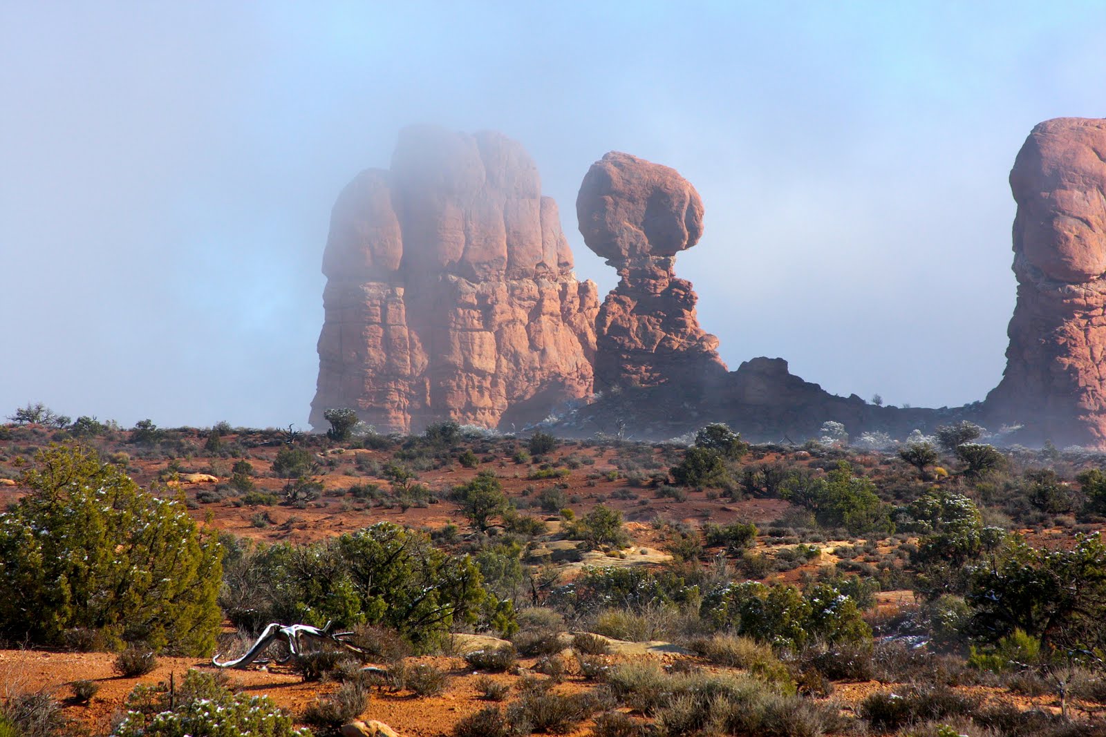
For a while, we 'scrambled', climbing up uneven staircase-like rocks that presented moderately easy passage in a vertical direction. There was a large arch, the kind of formation Moab is famous for. After a lot of posing for pictures the plan was to go up a 'fin'. This is a narrow slice caused by erosion of parallel cracks in the monolithic mass of sandstone that constitutes the entire region. It's tall, thin, and the only way up it is to hold onto a cable, thoughtfully installed by someone crazy enough to get up there without it. Of course, Tom and Martin just walked up the thing without touching the cable, and threw down a rope for me. 
Bill coming up the cable on the fin.

At this point, I should mention the weather. When we started out, it was overcast and cloudy, chilly but not cold. The wind was intermittent and not strong, but enough to drive the chill through fleece jackets. Bill had sent me a list of things to carry in my backpack, one of them was gloves. By the time we reached the arch, the high thin clouds had moved on, the sun was out. The temperature was pleasant, and I was grateful for that. I can't imagine all this exertion in hot weather, there's no way I could have carried enough water to sustain the day. 

Terry told me the best way to go up a fin is to ignore the fact that it's only a few feet wide with terrifying dropoffs on either side. Actually, he never used the word terrifying. He did mention that at home, he can walk easily down a length of rail on a railroad and not fall off. This is the same thing. Just focus on the place you can put your foot and don't think about what's on either side. It's true, our minds are our worst enemies. I can walk a rail too, but I'd be crazy to walk a rail 200 feet off the ground! I followed Terry's advice and just focused on holding the cable, leaning back a little, which I must say is sooooo counter intuitive. Turns out, it was way easier than I'd thought. The cable had little burrs in it that would have cut my hands, but Bill lent me some leather gloves. A burr did catch my pants though, and tore a hole. So I now have 'canyon' pants as a souvenir. They would become even more souvenir-like as the day progressed....

At the top of the fin, the land leveled out. This is not to say it was like the great plains of Texas, it was simply humpy without any more forbidding cliffs. We were on top, finally, of that massive sandstone formation that makes up much of the Colorado Plateau. The views were spectacular. Off to the northeast was a land of many fins and humps of eroded sandstone resembling the backs of enormous turtles. Beyond that, pristine snow covered the La Sal mountains, so aptly named with the Spanish word for salt. In the opposite direction we looked down into the canyon from whence we came, to the wide Colorado River in its deep, serpentine canyon, the almost maroon walls bordered by gold leafed cottonwoods. 

Bill had it in his mind that we would 'get out' by going north. He had a map but it wasn't terribly precise, and there were no marked trails other than the occasional cairn. After a while, there were no more cairns and we were bushwhacking, headed toward the canyon he and Tom could see from the highest vantage points. They had spotted a couple of possible routes they called Plan A and Plan B. I'm not sure which one was chosen, but it led to a cliff with an impossible drop, a sheer rock wall. It was now about 2:00 and the weather had changed from sunny to cloudy, from mild to chilly, snow was on its way. 

We backed uphill and took the alternate route which involved going down a narrow canyon between two fins. Even though this is normally hot desert country, the land between the fins gets all the water that runs off them during rain storms and the microscopic bits of rock that weathers constantly from them. It's positively lush down there, full of Mormon tea, tough stickery juniper trees, grasses, flowers, rose bushes, and lots of damp sand. Bushwhacking through the little canyon was slow work. At one point the only passage was past a juniper with a branch that had grown sideways and then bent as it hit the fin wall. The guys moved the branch aside and slipped past it. But the branch was right at chest level for me, and even with my pack off, it was downright painful to get past it, felt like I was being molested by a tree!
Plan A or Plan B???

The little canyon opened out onto another cliff but this one had a few narrow shelves and larger 'stairs' that led to the final major obstacle, a 30 foot drop. Time to get out those ropes again. I was terrified. This was the worst moment of the day, and after 5 hours of scrambling, climbing and hiking, I was tired. I didn't trust my shaky knees anymore but there was no other option. We could see the jeep trail at the bottom of the canyon. The way out was clear, just simply not accessible, in my view. The four men showed no sign of turning back, and I wasn't about to suggest it. I doubted actually, if we could have found our way back to the exact fin with the cable, and that was the only way down on that side. 

Bill set up a belay and this time he wrapped the rope around my waist. Martin simply scampered down the shelves and then slipped down a crack 'chimney' and was on the ground at the bottom. Well, bottom might be a misnomer, he was at least off the cliff. The canyon bottom was still far down a talus slope with a few more shelves to traverse. I sat for a few minutes and just tried to calm down. My heart was beating itself out of my chest. I don't think I've been this scared in a long time. I was looking my own demise in the face and there was no option but to trust these men and the ropes. And hope my knees would hold up. This time, it wasn't easier than it looked. 

Tom and Bill set up the belay with Bill noting there was nothing to brace himself against. Tom suggested a little sapling tree barely surviving in an inch of soil. Bill pushed against it with his feet and it toppled right over. Oh good, I'm going to be held up on the side of a cliff by a guy without a rock to brace against. But Bill dug in his heels and decided his weight alone would keep him from sliding off, in the event that I fell. I took off my gloves, now damp from the sweat of my palms. Just writing this, I'm having to wipe off my hands!

Set up to go, I inched my way down the cliff, hanging onto tiny crevices of rock, placing one foot at a time on the sandy, slippery shelves of rock. In reality though, the sand was damp, held well, and the shelf was wider than it had appeared to my terrified mind when I first looked down. The drop from the shelf to the skree below was still 30 or more feet. That aspect of reality had not changed a bit. The worst part was coming around the corner where Tom was standing. The 'corner' was an overhang of rock with quite a step from my shelf to the one he stood on. He told me exactly where to grab hold of the rock and then he put an arm around my back for support and I inched over to his shelf. There was barely enough room for both of us, but a wider platform, the top of a tower of rock, was below and I got down to that. Terry was already there. The rock we sat on had a gap between it and the sheer wall we'd just come down, forming the chimney. Since I had the rope on, I got to go first. Bill was still way up at the top belaying me. Tom dropped down to the platform and talked me down the chimney. After the terror subsided of being suspended in a crack with just a sloping slab of slippery rock below me, it was kinda fun. I had both hands on the rock opposite the one my back was pressed up against. There were some visible foot holds to stand on and lean against, but at the bottom, there was empty space bounded on one side by a very steep slab of rock. Martin was down there, he held onto the toes of my boots as they slid down the slab. I pushed my back into the wall and inched my way down. I could feel the rope tighten and knew Bill was doing a fair share of holding my weight as I slid. Eventually there was not a thing to hang onto and essentially Bill lowered me to the ground. It was only a few feet and Martin was right there. I had feet flattened up against the slab but they would not have had enough friction to support me if Martin hadn't been bracing from below. Finally I was on the real ground once again. I collapsed into a heap over with the pile of packs we'd lowered earlier.  Terry got down faster but it was a struggle for him too, belayed by Bill. Then Bill had to come down from way up above and Tom belayed him from the platform I think (I've since been corrected, Bill was NOT on belay! It's kind of embarrassing to be belayed if you're a real mountain guy. Not being a guy, I'm spared such ego, I'll take it when I can get it.) It dawned on me after a little bit to take some photos, so I got Bill coming down the chimney , and then Tom who slid down with what seemed like little effort and no rope. Monkeys. They're all monkeys. 

The rest of the way to the bottom of the canyon was a relative piece of cake, though it was steep and sandy with little angular rocks mixed in. It felt a lot like skiing. I tried to stay in the men's footprints so as not to create too much disturbance of the cryptobiotic plants that keep desert soils from eroding. Martin and Tom went on ahead at their faster pace to get the cars. At the mouth of this canyon the paved road leads back to where we'd parked a couple miles beyond.  I deeply appreciated their willingness to 'go the extra mile'.

We walked out on the sandy and sometimes quite rocky jeep trail that followed what is often a raging river, a periodic tributary to the Colorado. Evidence of high water was everywhere, plants mashed over towards the mouth of the canyon, some small trees along the edges with exposed roots, flotsam jammed up against boulders, and slick exposed rock on the river bottoms. It began to rain, a cold spitting rain. I packed according to Bill's list so I got out my rain jacket and was comfortably dry if not exactly warm on the walk out of the canyon. By the time we reached the paved road, it was snowing, small icy splats of snow that didn't stick, but would shortly. We waited under a shelter for about twenty five minutes before Tom and Martin showed up with the cars. This incredible day was finally at a close. 


Tuesday, November 2, 2010

"too" Boulder

After the almost fatal drive from Laramie to Ft. Collins a week ago, I thought I'd better get new tires. Winter is coming and I don't want to be caught in another situation like that with less than wonderful tires. There's a place my friend Dan Day recommended and he called ahead to get me the 'family' discount. While they put on the tires I took a little walk in the glorious fall weather; trees golden, red, and some still green in every direction, the little creek with a sidewalk along it full of squirrels dashing about, children playing in the park across the street, a lovely area. And I spotted a bakery. I don't eat grains anymore but the smell of fresh bread would ease my soul and besides I could pick up something for my mom who is feeling deprived traveling with me and my austere diet.

The bakery was in a small house with little Tibetan flags in the flower bed, nicely landscaped front yard and a large sign: Fresh Baked.

I stepped in through the door to no smells whatsoever. Inside the darker room when my eyes adjusted there was a conference table off to one side, the room had a tall desk with two people behind it who looked at me questioningly.

"Oh, this isn't a bakery?"

"No", said the slim young woman, "It's a dispensary."

There were no shelves full of product, nothing 'for sale' that I could see. Now my curiosity was beside itself. "A dispensary of what?"

"Medical Marijuana" she said, "Welcome to Boulder!!"

Friday, October 29, 2010

Old school memories

I lived in Boulder from the time I was 16 until I was in my mid-thirties. Highschool, college, marriage, three houses, several jobs, and a lifetime were spent here. I remember having a huge crush on a boy named David back in 1971. When he announced one day that he'd joined the Navy for 6 years, I was devastated. I walked from the school seven miles into downtown Boulder across open fields filled with grazing cattle. My eyes bawling tears, it was a slow trip. I grabbed hold of a fence to pass between the barbed wires and was horribly shocked three times before I realized it was electric. It caused convulsions and I thought until the third time, that I was having a heart attack. The current passed from hand to hand thru my broken heart.

Yesterday, I walked to the old school through paved streets, and a bosque of trees along South Boulder Creek. Amazingly there are still a few remnants of open fields and even a few cows, it's not entirely filled with businesses and houses. I don't remember the exact route I took then, but it felt like my life had come full circle. I do recall an old red caboose sitting on a section of train track in someone's yard, and sure enough, it was still there. I remember a little wooden bridge across the creek, and though it may not have been the same one, I crossed that way this time too. In 1971 it was spring, now it's autumn. Pumpkins were for sale along the old road, now a major artery into subdivisions. There is still a little farmland and some people make a few extra bucks off the land. The lake next to the school is cleaned up and features an RV park. The dangerous road alongside the lake was straightened out after the near fatal accident I'd had with Tom, Fred, and Grant in 1970, our junior year. And now, as then, there are no sidewalks, not even a dirt path. One is not supposed to walk along that road, but I did then and now, braving traffic and probably irritating more than a few drivers.

Scary Scary Drive

Friday, October 29

My mother and I drove from Los Alamos up to Salt Lake City a week ago today. We spent the night in Monticello, Utah, a little Mormon town with a Temple, a couple of inexpensive but clean motels, and an interesting little grocery store. I was a bit surprised to see so much Mexican food there, including moles,  nopales (bottled cactus), and pan dulces in the bakery section. They aren't used to foot traffic, we were almost run over by a giant semi tractor trailer that was turning as we crossed the street. I swear the driver never saw us, and probably walking people was the last thing he expected to see in the darkened street.

We drove to Moab the next day and had breakfast at a darling cafe at the north end of town. Most places appeared closed, which seemed odd to me in such a tourist town on a Saturday morning. This little cafe also sold antique collectables from shelves placed in the windows, ledges around the walls, and I think even the furniture was for sale. We placed an order and were given a plastic banana so when the food arrived the waiter could find our table. I've been given little flags, numbers, even colorful bandanas in places like this, but plastic fruit was a first. The coffee was excellent and the food good. We visited with a man who eats there two or three times a week when he's in Moab. He was a geologist at a nearby mine, working on contract, and lived in Ft. Collins Colorado. I love how people are willing to visit with people they've never seen before and will never see again. It's not just passing time, it's that quintessential human experience of visiting, learning something about someone, and maybe in some off-chance, it will somehow change your life.

The drive north through Utah was a stark desert drive with dark low shifting clouds and light play on the BookCliffs and that rough country west of Green River. I would have enjoyed seeing the museum of Natural History again in Price but we were in a bit of a hurry to get to SLC and go to IKEA. You see we were IKEA virgins and had heard how wonderful the experience of an IKEA is. We had no idea. It is situated about 30 miles south of Salt Lake City, a huge blue warehouse visible for a couple of miles down the freeway. We got there at 1:30 and didn't leave till 4:30. Didn't buy anything either, that would happen the next day. Just getting out of there required a store map, a compass, and my cunning navigation skills as my mother began to feel quite sick and we needed to leave. However the Swedish meatball plate, greek salad, and the array of desserts made eating in their cafeteria an experience, and one we would repeat on Sunday! We never did figure out what had made her feel sick.

After much driving around in the area where my son used to live, an area I thought I could find my way around in again, we found a hotel and checked in. Mom said she just wanted to rest, sleep cures most ills, so I dressed up and went to my friend Steve's 50th birthday party. He and his wife Sue have lived in SLC now for about 9 years and I've visited and stayed with them often. Our mutual friend Becky from Eugene Oregon was there and we had a wonderful time. There were about 25 people at the party. Sue's old friend Andrea, a chef and caterer from NYC, made the food and was herself an interesting and entertaining person. It was nice to see Jo, Steve's mother and Sue's mother too. Both have moved to SLC to be near the last grandchild for both of them. All the other grands have grown up, but Andrew is 12 and could still use some grandma influence. This is one family that has stuck together. When the kids moved away, the parents followed. So many families are scattered all over and some kids don't ever get to know their grandparents very well.

Steve got to have all his important women there for his big birthday. I was his neighbor 25 years ago in Albuquerque. I introduced him to Becky, my old friend from high school, and they dated for a while. Then broke up amicably, and eventually Becky introduced him to Sue whom he married. So, if it weren't for me, Steve would not have the life he has now. His path would have been down an entirely different road. I think he's very happy with his life, so I feel no guilt.

On Sunday, I visited with Becky and Andrea for breakfast, then Mom and I went back to finish our IKEA experience. I was specifically looking for a desk to put into a 5 foot wide space in my bedroom. IKEA had exactly what I needed, plus we purchased all kinds of other stuff including a bag of frozen Swedish Meatballs, some salty licorice, dark chocolate, and lingonberry preserves. IKEA stuff comes in build-it-yourself pieces, which fortunately all fit into the van and we were on our way.

Early Monday morning, long before sunrise we headed east on I-80. It was raining and by the time we got up in elevation the rain became a blizzard. Huge flakes splatted against the windshield and monster trucks, acting invincibly, zoomed past us and pummeled my view with slush. I'm surprised the wiper blades didn't fly off the car they were moving so hard and fast. It was tense going so when we reached an intersection with a gas station I pulled off and we went in for coffee and a potty break. Of course everyone who came through the door had a weather related story. Further on it was bad news, slick roads, no plows through that section yet, etc. When it was daylight we went on. The roads weren't too bad, slick in places so we never got above 45 mph. I could tell this route to Boulder was not going to be a simple 8 hour trip. We stopped at the visitor's center in Evanston. The wind was howling and snow blew across the road like a blizzard. I had to pee so badly I was about to burst.  I shouldn't have drunk all that coffee at the gas station. The visitor center's electricity was out, so the two ladies running the place wouldn't let us use the restroom. Their toilet flushers are electric! OMG, our culture has become so dependent on electricity we can't even flush the john by ourselves!

My mother noted that the men's room had doors on the outside of the building, so we casually walked out of sight of those women, then dashed into the men's room. Mom held the door open slightly so some daylight would come in, and we took turns using the handicapped toilet. I guess someone else probably flushed it after the electricity came back on. I wasn't about to leave any yellow snow in that wind, even if there had been some bushes to pee behind!

Across Wyoming, there is wind. Perpetual strong wind, and these days: wind farms. I never saw so many of those giant windmills. In one particularly icy stretch, when we could barely go 20 mph, I spotted a ridge and did a quick count of ten, then visually multiplied it to get around 60. I know they cost at least $1million apiece, so that is quite an investment by some company. And every one of them was whirling around like a kid's pinwheel on a stick. I wonder how much of that electricity is used to flush toilets?

In that same area, on the opposing lanes of I-80 a trailer had been blown apart. The tractor and the flatbed of the trailer were on one side of the two lanes, and all the goods, aluminum skin and frame were on the other side. I was busy trying to stay on the road. Mom said she couldn't really see what the contents of the trailer were. Looked like mattresses and boxes of fluffy stuff to me the few times I was able to glance over. There were several emergency vehicles but the tractor was upright and I doubt the driver was hurt. What a mess though!

We gassed up in Laramie and had dinner downtown. We spotted several steak houses, but when we walked up to them after parking, they were all closed for business. We spotted a bar but they didn't serve food. This is a university town! There ought to be bars and food everywhere. Eventually we did find a nice little restaurant that served buffalo burgers and sweet potato fries. So, filled up, we headed south on 287, the old north-south road that goes all the way into New Mexico.

I had no idea what I was facing. The reports we'd gotten from gas stations and truck stops along the way showed little weather in that area, it was all to the north, but as the road climbed in altitude, the road went from dry to wet to black ice. On one hill, I gently pushed the brakes to find I had no traction at all. So I slipped into second gear and slowed down, kept a steady grip on the wheel and just went around the curves hoping we would not go straight off a cliff. Climbing up the pass, a truck was tailgating me and I kept slowing down. He must have noticed he had no traction either because at the top of the pass several trucks were pulled over. I pulled in front of them, and so did he. We just sat there for ten minutes. I tried to quit shaking and spent a little time flexing my hands, they'd both gone numb from gripping the steering wheel.

"What do you want to do?" my mother asked.

"Well, it's not going to get any better, so spending the night here is probably not an option. If we can get to a lower elevation, it should warm up. But who knows when that'll be?"

I discovered that if I kept to the shoulder there was a little snow for traction and the rumble strips gave at least one tire a grip on the road. We oozed down the pass at 15mph and eventually the black ice turned back to wet pavement, and I could drift back into the road. I noticed that nobody had followed. For the entire drive to the bottom of the pass there was just blackness in my rear view mirror. On dry roads we picked up speed and made it to Ft. Collins by 8:30. It was another hour and a half to Boulder but it was smooth sailing after a break in a grocery store parking lot to stand up, stretch, and celebrate our safe passage.

We pulled into the Barta's driveway at 10:00. Sixteen stressful hours after we left Salt Lake City. Whew.